
COUNTY AD-HOC COMMITTEE OFFERS TO SPLIT PLEASANTON; GIVES SHORT SHRIFT TO ALTERNATIVE MAP
By Steven Tavares
steven.tavares@eastbaycitizen.com
Follow @eastbaycitizen at twitter
The state is not the only government body doing more than moving the furniture around its legislative boundaries, local government is also dividing itself into district’s at the county-level.
Two redistricting maps released today by an Alameda County Board of Supervisors ad-hoc committee and the Community Development Agency offer two proposals meant to even out the redistribution of population towards the county’s eastside.
The proposed reconfiguration maintaining most of the current boundaries is already attracting criticism from officials in Pleasanton where that city would be split between Supervisor Scott Haggerty’s District 1 and Nate Miley’s District 4. The previous map used the natural boundary of Interstate 580 as the boundary and placing Dublin in Miley’s district. The newest proposal would drop the boundary south below the freeway and bisecting Pleasanton. Aside from a movement of the boundaries in the north around Albany, there is very little difference in the map created a decade ago.
Despite the minimum changes for the 2011 map, an influx of residents towards the valley has become one of the top issues concerning the changing population of the East Bay and entire region.
No city in Alameda County came close to the increase in population in Dublin, where it grew by 53.6 percent to 46,036 people. Its Tri-Valley neighbors, Livermore and Pleasanton increased by 10.4 percent over the last 10 years, according to the U.S. Census. Those totals, though,represented average increases within the state, where the population grew by 10 percent. Alameda County, by contrast, grew by a measly 4.6 percent.
Like redistricting maps for the state Legislature and House of Representatives, each region must contain relatively equal numbers of people. In those regards, the largest shift in the county will occur in Supervisor Wilma Chan’s District 3, where it is 22,000 people below the target variance of 302,000 people and Haggerty’s District 1, which represents the largest positive variance topping over 29,000 new residents.
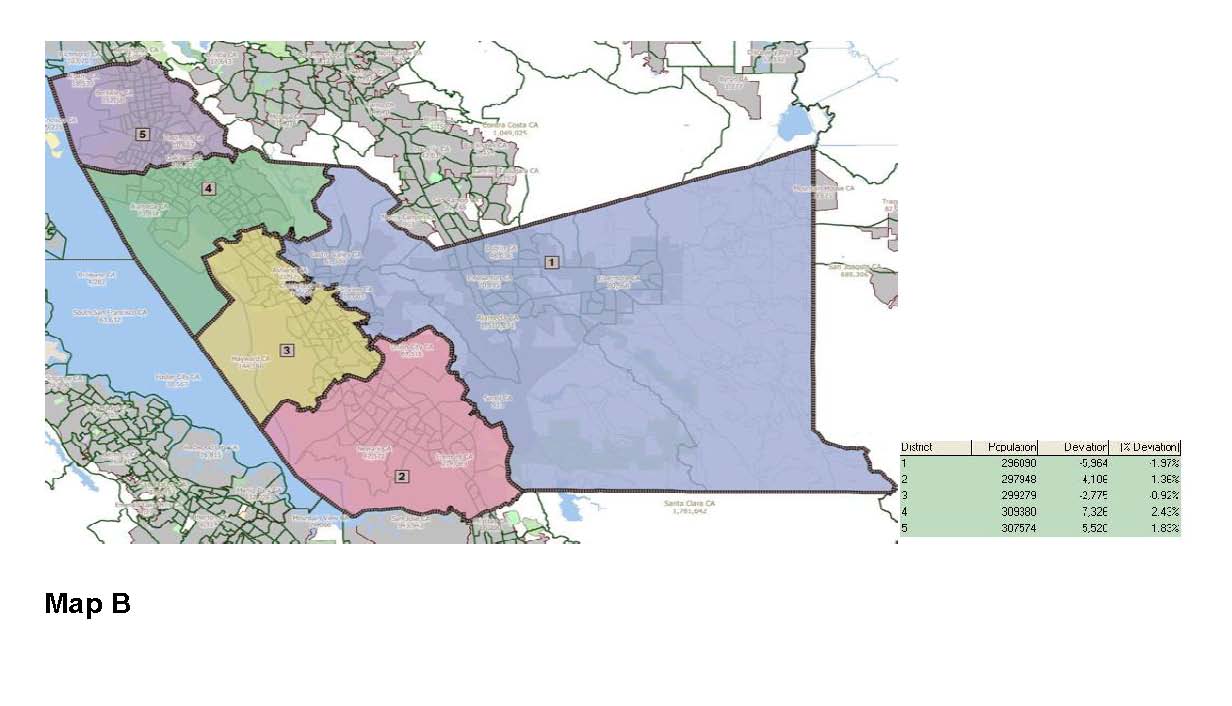
The second map, also created by the ad-hoc committee composed of Supervisors Haggerty, Miley and Keith Carson, is far more ambitious and vastly less complicated than the current setup, but unlikely to be approved.
Map B would stack Districts 2,3,4,5 along the San Francisco Bay and create one super district encompassing more than half the topography of the county. Carson’s District 5 in the north would slide south, while Miley’s District 4 would slide to the west to also represent Alameda. San Leandro would remain in Chan’s District 3 and Nadia Lockyer’s District 2 would gain more of Fremont from District 1.
The likelihood of Map B gaining any foothold does not appear likely. In the PowerPoint presentation for the series of six redistricting meetings in the next 10 days starting today in Dublin, there is no mention of the more radical proposal. The county’s new district boundaries could be approved by the Board of Supervisors as early as the July 12 meeting and finalized two weeks later.
ALAMEDA COUNTY REDISTRICTING MEETINGS
May 31, Dublin City Council Chambers, 100 Civic Plaza, Dublin, 6-8p.m.
June 1, Hayward City Hall, 777 B Street, Hayward, 6-8 p.m.
June 2, San Lorenzo Village HOA, 377 Paseo Grande, San Lorenzo, 6-8 p.m.
June 6, Northbrae Community Church, 941 The Alameda, Berkeley, 6-8 p.m.
June 8, Alameda County Admin Building, 1221 Oak Street, Oakland 6-8 p.m.
June 9, Fremont Library, 2400 Stevenson Blvd, Fremont, 6-8 p.m.

Where's the proof?
LikeLike
Back in the early 90's the Board had to split up San Leandro in order to keep that black incompetent woman Mary King on the Board.
LikeLike
Anonymous…learn to spell or they'll get you…no need for racists comments…doesn't help your “cause.” Maybe pick up a book and learn about the tri-valley before you type. Plenty of whites, blacks, asians and indians in the tri-valley, getting along too.
Wake up, jackhole!
LikeLike
Pleasanton was created for the whites to escape all the slant eyes, porch monkeys and towel heads. it sad that it has to be part of alameda county
LikeLike
@John: Glad you at least own up to your communist, homosexual agenda.
LikeLike
Anonymous 10:18PM…
Have you been to the tri-valley lately? My neighbors are Asian and Indian…there is a great influx of diversity in the area…come check it out.
LikeLike
Map B was withdrawn from the record on the assistance of Supervisor Haggerty. Haggerty spoon feed the words to the athour of the map. Vice Mayor of Pleasanton asked staff to keep map on the record; approved.
LikeLike
What about West Dublin? LOL
What about the many communist homosexuals in the Tri-Valley? I often meet with them at secret locations in the Tassajara Valley as we conspire to push our dark agendas.
Watch out- we just turned your 35-year-old son gay! We also made him into a supporter of Medicare, Medicaid and Social Security, so he's a dirty hippie! Also!
LikeLike
East Dublin, Pleasanton, and Livermore should succeed from Alameda and become their own county called “White County”. They should be separate from the communist homosexuals in the East Bay.
LikeLike
Promoting the general welfare is in the United States Constitution. Why do you hate America?
BTW, the Contra Costa County Board of Supervisors cares about people as well. Perhaps you would like the Tri-Valley to become part of Missisippi?
LikeLike
That's so they can keep 3 Pro-Welfare Supervisors on there. But then there's Nadia so what the hell, Alameda County will continue to be a hell hole. I wonder if Tri-Valley can break off and join Contra Costa????
LikeLike